
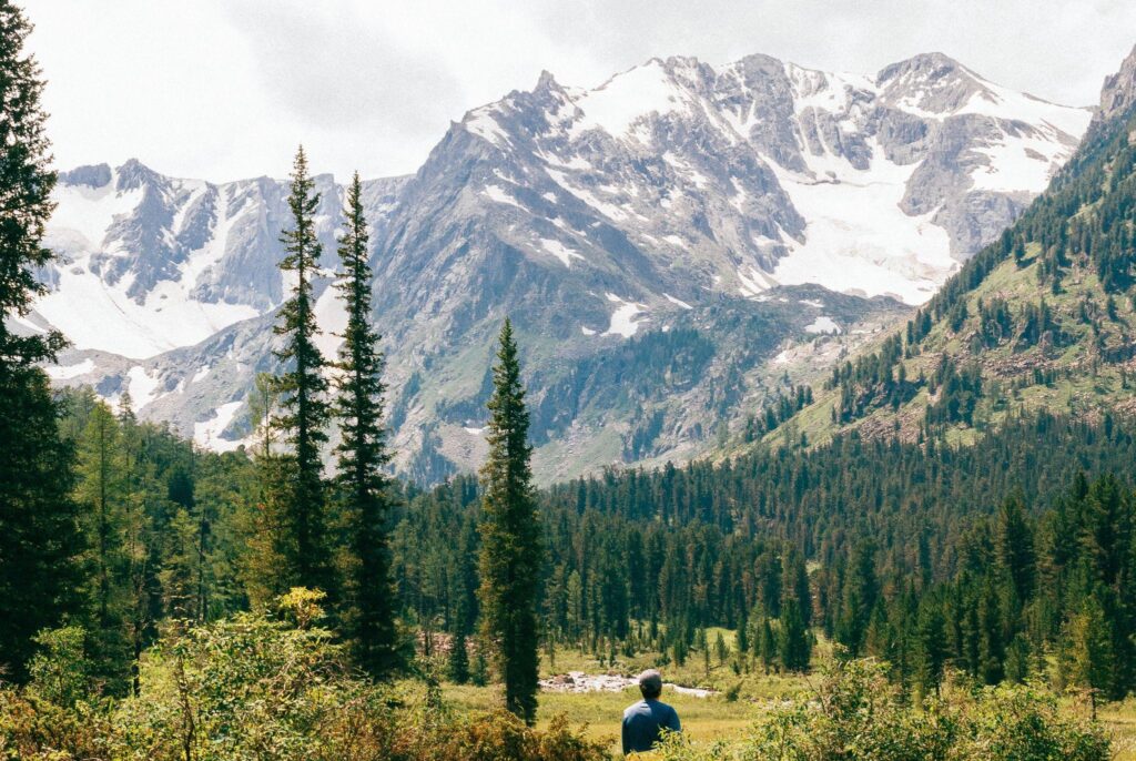
The Altai region, a land of forests and high mountains, is located in southern Siberia. There are more than 17,000 rivers, from large to small, flowing through its territory. People come here for adrenaline and tranquility at the same time. And also to visit the unique nature reserves and to admire the unique beauty of this wonderful place.
Lake Teletskoye
Lake Teletskoye is located in the northeast of the Altai Mountains, at the junction of the Western Sayan Ridge. The name in Southern Altai is Altyn Kӧl, and in Mongolian Altyn Nuur, both of which can be translated as “Golden Lake.” It is included in the UNESCO World Cultural and Natural Heritage List as part of the Golden Mountains of Altai complex. One of the centers of tourism and recreation of Altai – the site.
Lower Multinskoye Lake
The lower of the cascade Multinskiye lakes. Length 2370 m, width – 900 m, the average depth – 21.5 m, coastline length – 6570 m. It is located at an altitude of 1627 m.
The basin is a bathtub with a flat bottom and rather steep walls. Lower Lake is the third largest lake in the Katunsky Range. There are well equipped tourist parking lots at the lake. Parking lots are paid, but you can visit them freely.
Srednee Multinskoye Lake
The second lake from the bottom of the cascade of Multinskiye lakes. It’s length is 1990 meters, width is 750 meters and average depth is 8 meters. Lake Srednee Multinskoye is located at an altitude of 1634 m.
Kuiguk Lake
Lake Kuiguk is located in the basin of the Multa River, at the head of its first major tributary, the Kuiguk River of the same name. The lake is about 1 km long and less than 400 m wide, and is located at an altitude of 2000 m. The lake spreads out in the southern part of a rocky gorge. The left bank is formed by a high stone wall, reaching up to the water surface. The right bank is characterized by more gentle terraces. Deeper into the lake are capes, occasionally overgrown with cedars, from the surrounding mountains fall numerous mountain streams.
Kuiguk waterfall
The waterfall flows out of Lake Kuiguk, forming the river of the same name. It is located in the northwest part of the Katunsky ridge. The height of the waterfall is about 30 meters.
You can reach the waterfall only on foot or on horseback. In dry weather the trail is easy, the length from the village of Maralnik-1 is about 16-18 kilometers – says Yurovskiy Kirill.
Akkemskoye lake
From the Altai Ak-kem – “white water”. Located at the foot of the northern slope of Mount Belukha in Ust-Koksinsk region of the Republic of Altai. It is fed by melted water of the Akkem glacier.
The basin of the lake is a trough-shaped mountain valley, formed by the activity of the glacier. The lake shores are composed of friable glacial deposits and covered with moss-bush tundra. The lake stretches from south to north, its length is 1350 m. The width of the lake is 610 m. The shoreline goes down quite steeply and reaches its maximum depth (about 15 m), which prevails in the lake. The average depth of the lake is 7.8 meters.
Lake Kucherlino
Kucherlinskoe – from South Altai Kajur-ly or Kudyurlu – with salts. It is located at the foot of the northern slope of the Katun Mountains in the upper reaches of the river Kucherla. The nearest settlements are Kucherla settlement and Tyungur village. From the village of Kucherla to Kucherla Lake there is a horse trail of 34 km long. Tyungur village and Kucherla settlement are connected by a 4 km long road.
Katun
Katun is a river in the Altai Republic and Altai Territory. The river has its origin on the southern slope of the Katun range near the town of Belukha on the Gebler glacier. Merging with the Biya, 19 km south-west of Biysk, it becomes the Ob River, one of the largest in Siberia. The Katun is 688 km long. The basin area is 60,900 km².
Stone mushrooms on the Chulyshman
Stone mushrooms are located in the Akkurum tract in Altai where the channels of two rivers, Chulyshman and Chulcha, join. The height of some reaches 7 meters with the thickness of a leg up to half-meter.
Stone mushrooms are mushroom-shaped geological remnants. The mechanism of mushroom formation may be different: erosion, weathering, the effect of glaciers, and the dissolution of the surrounding rock. Stone mushrooms are found in many countries.
Big Aktru Glacier
Big Aktru is the largest glacier in the area. It is separated from Maly Aktru by a short ridge ending with the Kara-Tash peak. The glacier occupies an area of more than 11 km² and has a length of about 8 km. From the south-east the glacier is separated from the gorge “Lamb’s foreheads” – two rocks with smooth tops, polished by the activity of the glacier, which 20-25 years ago passed through them, connecting with its right arm and forming a common channel. Now the glacier has retreated (according to scientists’ estimates, the Right Aktru decreases by about 6.5 meters per year, and the Left Aktru by about 10 meters). From the southwest – in the upper part of the glacier – the circus closes the Aktru Pass, beyond which the Right Maashey Glacier, belonging to the neighboring basin, extends. Among the peaks of the ridge, surrounding the glacier, is the highest peak of the area – Aktru (4075 m.). In the area of the lower third of the glacier, at a distance of about 1 km from the edge of the tongue, behind the moraine at an altitude of 2840 m is the Blue Lake – an object of frequent tourist attention, also serving as a starting point for athletes climbing to the surrounding peaks.


